Monday, August 17, 2020

Route 66 Gallup, New Mexico to Amarillo, Texas: Las Vegas KOA to Santa Rosa, New Mexcio, May 29 Day 8

After a good night's sleep and rest we are getting ready to roll. 

A cooler morning for a change here at the Las Vega, New Mexico, KOA Campground.

Light windbreaker/jacket needed.
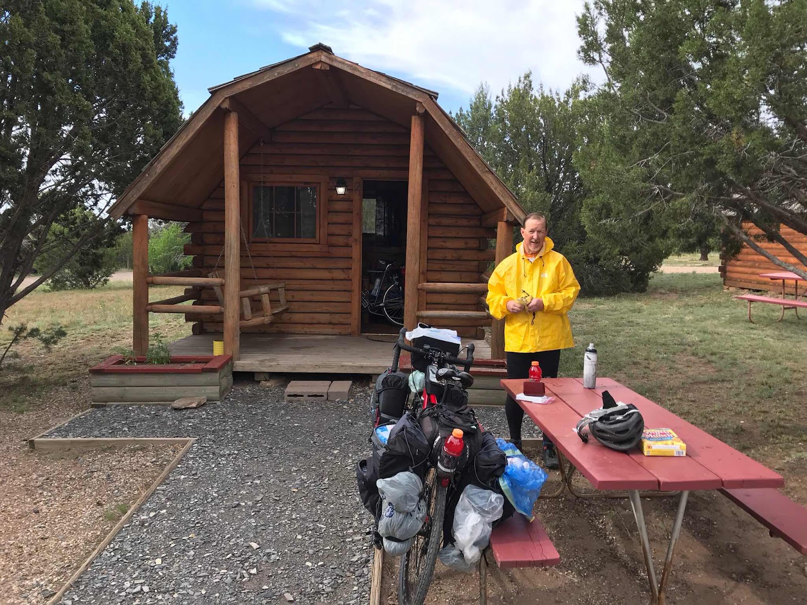


The cabin has little extra room to maneuver when occupied by two guys, a bunk bed, a regular bed, and two bikes, so we do our packing and loading outside.

That's Brother Mark awakening and greeting the dawn in his usually good spirits.

Our first stop involves the Subway sandwhich franchise just outside the campground.


A beautiful morning and excellent road for cycling.

Notice the super wide smooth paved shoulder. A safe way to travel.


Route 66 presents as a living museum inviting reflection into its history: What might be the story behind this vintage abandoned auto and the people associated with it? Where were they from? Where were they headed? Did they reach their destination? 

Route 66 may be traveled for many different reasons. Many seek the zany tourist element of Route 66. 

I seek the living history embedded in the Mother Road. So many lives. So many destinies. So fascinating.


All that remains of an old bridge. Perhaps an original Route 66 bridge replaced by the newer alignment we ride today.


Meet Steve.

He's not our long lost brother, but we do share some rugged, good-looking characteristics, eh? 

Steve heads west. (We pedalling east.)

Steve has headwinds. (We don't.)

As a veteran cyclist traveling alone, Steve's target destination of Phoenix, Arizona, home to his son, awaits him.


Our eyes feast on beautiful and wide open spaces today.

But our stomachs want more than scenery.

Unfortunately, the 99.1 km (61 miles) we cover today offer us almost zero opportunities for places to eat. 

We had a big breakfast at Subway in Los Vegas this morning. 

We ordered extra subs to carry with us for our next real meal.

(We fuel and feast on, or at least tolerate, powerbars and sport drinks while we pedal along.)

We hoped this remote vingate "cowboy bar" would be open and serve food. 

Part of our hopes were realized. 

Maesta's Lounge and Bar Games was open, but wasn't serving food. Cold drinks yes.


Standing outside Maesta's Lounge and Bar Games, I stretch my legs, and for some strange reason wear my windbreaker. I don't recall it being cool at all.

In the middle of this weekday, we are, no surprise, the only customers. 

I googled this place. Many 4.9 star reviews. "A good place to go." I'm sure it is. 

But it is also, as far as we can tell, just about the only place to go for quite some distance.

No food served in middle of the day. No problem. We brought our own slightly travelled subs from our breakfast stop in Las Vegas near the KOA, and it's ok for us to eat our subs in the wonderfully quiet, dark, very vintage establishment. 

The restrooms (American)/washrooms (Canadian) rank high among both the cleanest and oldest I ever used. Talk about stepping into a Time Machine. 

The gentleman holding down the fort during this low traffic customer day, quietly accepted payment for my two cans of Coca Cola. (I wouldn't want to dehydrate now, would I? :-) 

During our brief stay he finsihed up one re-run espisode of Bonanza on the Western Channel, and began another, enjoying the super large screen TV and impressive surround sound mini-theater.


Down the road from Maesta's refueling station, we cross yet another brown water river so typical of the region.


Way behind us, under those dark, moisture-laden thunder-head clouds sits our starting point, Las Vegas, New Mexico. 

But the clouds are not sitting still. (See next photo.)


Clouds closer. Clouds darker. Clouds moving our way, faster than we move away from them.


Can almost smell the rain.

(See our road behind us riding the swells of the rolling hills?)


Didn't see any. But we know they are out there.


No time to dawdle. We aren't the Storm Chasers. We are the Storm Chased.

Full speed ahead towards our destination for the night. 


With gravity on our side, and the wind at our backs, we arrive at our destination just before the storm clouds. 

(This being Storm Chased every evening becomes a pattern that will eventually create serious issues for us in a few days when we arrive in Amarillo, Texas.)

Another Classic Vintage Route 66 Motel. Much the same as it was decades ago.


Nicely maintained, clean, comfortable rooms.

Truth be told, after almost 100 km (62 miles) today, I probably could have slept soundly on the park lot. 

But I'm grateful for this bed. 


Amost right across the street, Joseph's Bar and Grill.

Excellent Mexican food supper. 

Really fine family owned restaurant for fine, hungry families.

Gift store loaded with lots of nice Route 66 memorabilia.

Tired, but full and happy, we return to motel.

We attend to preliminary packing for tomorrow, and call it a day. 


Maps make it look short and easy!


The elevation graph makes my cyclist heart smile, especially after our traversing of the so-called "Foothills of the Rockies" a few days ago.


Had a few short but steep descents reaching so uncomfortably high speeds for me. 

As heavily loaded as we are, the fast downhills feel dangerous. 

At 63 kph (almost 40 mph) I'm not fully in control of the bike. Can't stop quickly. Can't turn effectively. 

Every little bump gives my bike a severe case of the wobbles.


Sunday, July 26, 2020

Route 66 Gallup, New Mexico to Amarillo, Texas: May 28, 2019, Day 7 - Santa Fe East to Las Vegas, New Mexico


The Post for this day on the Shelley Brothers Cycling Adventures Facebook Page:

Greetings from Route 66!

Today on Day 7 of our ride we pedalled 52 miles (84 km), climbed over 3,000 ft (915 metres), and reached a new high elevation of 7,566 ft (2,300 m).

We are tired. Need to rest.

Internet poor in this area.

We’ll be in reasonable civilization tomorrow and will provide the stories and photos you all breathlessly await!

**************************************
That was then. This is now, a year later. Here's the day as I mostly remember it..........


Within minutes of leaving our warm KOA cabin, we find ourselves climbing through the "foothills" of the southern tip of the Rocky Mountains. 

(*Foothills* my asterisks! If it looks like a mountain range, feels like a mountain range, and smells like a mountain range, then it is a mountain range.) 

Very steep climbs on Interstate 25 on this sunny but chilly morning. (This stretch of road is a lot steeper than it looks!)


After "enjoying" the Interstate for awhile, we gratefully return to historic Route 66, and find ourselves crossing Glorieta Pass at 7,500 ft (2,250 m), about the same elevation as the Continental Divide crossed between Gallup and Grant a few days ago.

This peaceful segment of highway once echoed with the ugly sounds of war for two days in March 1882.

Many historians consider this a game-changing battle of the American Civil War Between the States.

Confederate troops from south in Texas literally shot their way northward through New Mexico with the goal of capturing the gold and silver mines in the territories of Colorado, Utah, and Nevada which would nicely feed, clothe, and weaponize their troops in "The War Against Northern Aggression" as they called it.

Significantly outnumbered and out gunned, the sparse Union troops in the New Mexico didn't stand a chance clashing with the Rebel Army head on and nose to nose.

Union leadership realizing the deck was stacked against them, they answered the brute force of the Southern Army with clever strategy.

Rather than being slaughtered by huge Confederate Army, the Union Army quietly sent most of its troops around and then behind the sizable Confederate Army. For appearance sake, a smaller Union Army contingent remained in front of the Confederate, probably to give the Rebels someone to shoot at!

Meanwhile, the Union soldiers well behind the Rebel forces started attacking their supply wagons and dismantling the supply lines connecting the advancing Confederate Army with Texas.

Currently unaware of this tactical kick in their butt, Southern soldiers enjoyed crushing the seemly diminished Federal troops blocking their march towards the mines.

But soon the Confederates started running out of  ammunition, and breakfast lunch and dinner couldn't and wasn't being served. Oops. They discovered their tail got cut off.

Overnight, the hungry and ill supplied Rebs became the pursued, not the pursuers. They literally ran for their lives hightailing it back to Texas. In the true spirit of spiteful war, Yankee troops mercilessly chased and slaughtered the desperate Confederates.

Not a fun story for either side to tell or be proud of.

The defeat was so decisive, the Confederacy abandoned its plan to capture the wealth just north of New Mexico.

Some historians speculate the outcome of the entire North and South conflict could have gone the other way had the Confederate States secured and leveraged the vast quantities of Union gold and silver to finance their troops against the North.

We rode through the middle of the battlefield at Glorieta Pass.


Just over the Pass, I'm getting hungry and thirsty.

I thought I was getting delusional.

But this huge Coca Cola can is real.

Just not filled with Coke.


But some real Coca Cola was literally just down the road around the bend.

Nothing more enjoyable after visiting the blood and guts of a battlefield site than to eat a delicious breakfast of hamburgers and fries.

We figured if we were lucky we might find a gas station with a convenience store where we could buy some of those stale miniature chocolate donuts for breakfast.

But hallelujah, rounding a curve in the mountain road a Dairy Queen called our name. Such an awesome and thoroughly American Experience.


And as if eating delicious hamburgers for breakfast weren't thrilling enough, for they truly were delicious, we also had the opportunity to help the Avengers save the Universe from Thanos.

This DQ is more than just a regular fast food joint.

While we were the only customers present on this rather early pre-tourist season morning, the layout and furniture of this establishment indicates it serves as a solace of sanity for the teen and young adult population in this relatively remote mountain community.

Video games, large screen TV, lots of seating and lots of relatively inexpensive tasty food suggests this DQ is the social center and preferred destination of the region's youth.

(But all the youth were apparently all sleeping in this morning. We had the entire place to ourselves.)

Felt like the perfect blend of capitalism and drop in center.


Though I only have one photo to share, our brief tour of the remains of the extensive pueblo in the Pecos National Park near the town of Pecos, was a highlight of the trip for me.

Like Route 66, one steps into a Time Machine on this location. Impressive. Breath-taking. Inspiring. Humiliating (as yet another story of European and American imperialistic arrogance, greed, and cultural insensitivity. We are slow learners sometimes).

Like the huge structure in photo above indicates, a sophisticated culture and society thrived here long before, and for a short while after, the Spanish, Mexican, and Americans arrived.

This introduction from the Park's website captures the cultural, economic, and military significant of this civilization:

Between the towering Sangre de Cristo mountains and the flat-topped Glorieta mesa lies the Glorieta Pass, through which a continuously unfolding story of human culture has traveled to and from the Pecos Valley for thousands of years. 

Cicuye, later Pecos, became known as one of the most powerful of the northern New Mexico pueblos. Why? Location, location, location. For one thing, it was at a higher elevation, 7,000 feet, where the growing season was shorter but the position more defensive. The Great Plains lay to the east of Glorieta Pass, while to the west there is the Rio Grande Valley and the Colorado Plateau, which in turn led to the Gulf of California, Old Mexico, and lands beyond. Whoever controlled the pass controlled the migration and trade routes of a vast region.

Pueblo and Plains Indians, Spanish conquerors and missionaries, Mexican and Anglo armies, Santa Fe Trail settlers and adventurers, tourists on the railroad, Route 66 and Interstate 25...the Pecos Valley has long been a backdrop that invites contemplation about where our civilization comes from and where it is going.


Keep your eyes open and be careful where you step!


Between the high mountains around Glorieta Pass and the seemingly endless expanse of the Great Plains still ahead of us, we encounter the "Razorbacks."

That's razorback as in a wild hog with a series of pointy ridge-like bumps on its back.

We didn't see any hogs.

The Road is informally referred to as the Razorback because of the multitude of repeated series of steep descents and ascents comprising part of the slow over-all descent towards the Plains.

I've never pedalled uphill so much to accumulate an overall decline in elevation!

But it was, even in its challenging and slightly psychologically maddening way, kind of fun. (At least at the end of the day when you can say to yourself, "Wow. I actually rode that!"


Another glimpse of the Razorback.

That's Interstate 25 humming along beside us.


We had opportunity to meet two other cyclists on this trip.

(Not many cyclists seemed to be pedalling our route.)

You see me, brother Mark, and Matt.

As soon as I saw Matt coming towards me while gaining speed pedelling UPHILL, I knew he was an athlete. He is. Runs marathons. Attends university on a track scholarship.

He's heading west with California as his destination. He's hoping to get to Santa Fe tonight.

That's where we stayed two nights ago.

He might make it. He's fast enough.

But we told him about last night's KOA Campground with the clean cabins :-)

He might stay there.

We admired his energy.


We finally arrive at today's destination.

This photo was taken the following morning, but it gives you an idea of our KOA clean (but this cabin aged a bit more than last night's) cabin.

The entire campground manifested a bit more age and wear and tear than our five star stop last night, but the accommodations were appreciated.

Supper featured dehydrated pasta once again raised from dead by the application of life-giving water, supplemented by potato chips and sugary things for dessert.

I had to run around in the shower stall to get all wet from the pencil sized single "torrent" (Not!) of water dripping from the shower head. But no complaints. Just great to get the layers of dirt, dust, sweat and sunscreen off my body.

We fell asleep happy and tired and eager for tomorrow's adventure.


Saturday, March 14, 2020

Route 66 Gallup, New Mexico to Amarillo, Texas: May 27, 2019 Day 6 - Santa Fe Plaza to East Santa Fe KOA


Brother Mark composed this description of today's ride:

THE GREAT SOUTHWEST ROUTE 66 ADVENTURE
Day 6 (May 27, Monday)--Santa Fe to (almost) Glorietta Pass (east of Santa Fe)

After yesterday's mega-adventure, today served as a semi-recovery day.

After spending a leisurely morning (re)packing, we made the less-than-a-mile trek to the historic Santa Fe Plaza, which one could argue is the birthplace of the "modern" (aka "cowboy") Southwest.

Many people asked about our trip, and seemed genuinely interested.

After walking around the square, taking in the ambiance, architecture and art, we found our way to the Blue Corn Cafe for a wonderful New Mexican food lunch.

Today's ride was 14 miles (23 km) from the Plaza to the Santa Fe Journey KOA, east of the city.  It was an up and down ride, but mostly up.

Because the weather continues to be windy and cold, Kent suggested that we rethink our tent camping strategy, lest we end up in Oz, or some similar location.

So we "upgraded"our tent site for a KOA "camping cabin"--a simple 13'x16' wooden cottage with bunk beds and one full bed (both with mattress pads).

Nothing fancy at all, but at least we didn't have to worry about our tiny tents blowing away to who-knows-where (with us inside them)!

We took advantage of the laundry facilities. (Imagine the aroma of six sets of stinky bike clothes.)

The laundry room was decorated in full blown 'Route 66.'

Among other things, we tried our hand at cooking dehydrated lasagna on our 'rocket' camp stove.

Except for me spilling a bit all over the front of Kent (it looked like someone threw up on him), it went pretty well!

[Editor's note: I'm pretty sure he deliberately threw the sizzling brew at me. But why? What did it do to deserve this? I'll tell you why: Brother Mark has always believed that Mother liked me best(aka, The Smothers Brothers Syndrome) , and sometimes, despite the steel-like grip he has on his inner child, it occasionally finds some kind of sinister expression. He has a real problem. He just doesn't know it. And don't tell him. I'm not sure if he actually reads this blog, so I think I'm safe most of the time. Perhaps someday he'll get therapy.]

We should sleep well, and be ready for a big day tomorrow.


Downtown Santa Fe Plaza functions as another Time Machine along Route 66 enabling visitors to see and sense the Old Southwest.

Santa Fe's "real" name is La Villa Real de la Santa Fe de San Francisco de Asis, translated "The Royal Town of the Holy Faith of Saint Francis of Assisi."

Native American's knew it long before the Spanish as as Ogha P'oge ("White Shell Water Place").

Santa Fe, founded in 1610 as the captital of Nuevo Mexico,claims title as the oldest State capital in the USA. This "city" has been continuously inhabited since 900 AD!

As a capital it served as the strategic economic, military, and governing epicenter of the region passing through Spanish, Mexican, and American ownership throughout the birth and settlement of the old Southwest, It has been referred to historically as the "Washington D.C. of the Old West."


Native Artisans create and sell one-of-a-kind art for wearing and decorating.


Desperately requiring fuel for our awesome athletic bodies, we each enjoy the largest tostados imaginable.

If you look closely you will see we are not fat or obese. We are just solidly built :-)

(Despite burning over 4,000 calories per day, I gain weight on this trip. Couldn't help it. Southwest Mexican food is amazing!)


We pause in the Plaza before striking out towards today's destination.


This photo captures the gist of our riding terrain today.

Up and down, up and down, up and down.

Wide paved road shoulders for riding are so nice.


True Story.


Compared to our micro mini cycling tents, tonight we stay in the Taj Mahal.

Sitting on the porch I pose pretending to be an old man. It's fun to make-believe occasionally :-)


Definitely an upgrade from a nylon tent!


KOA stands for "Kampground of America," a national franchise of camp grounds for recreational vehicles and tenters.

So I think a cabin in a KOA should be called a Kamping Kabin. It only makes sense, eh?

Therefore are staying in a KK at KOA. K?


Product placement?


Closing my eyes, imagining and remembering my delicious lunchtime Tostado really helped me eat this.

Actually, it was rather good.


Notice the spike on the right hand side of today's speed graph?

That might be a land speed record for me on a bike. (Okay. I admit it. I'm not a racer. On purpose.)

Flying 62 kph (38 mph) downhill on a heavily loaded bike starting to shake like a Space Shuttle upon re-entry gives new meaning to the phrase "fast and furious." Especially when I realize I have no way to actually slow this rig down, much less stop it.

Kids: Do not try this even with (crazy) adult supervision!

I'm setting a bad example here, and not proud of it. (But it was a great adrenaline rush!)

Thursday, March 12, 2020

Route 66 Gallup, New Mexico to Amarillo, Texas: May 26, 2019 Day 5 Bernalillo to Santa Fe, New Mexico

I posted this entry for the day on our Shelley Brothers Cycling Adventures Facebook page:


Day 5: Bernalillo to Sante Fe, New Mexico.


Brother Mark predicted this would be our toughest day’s ride for our entire trek. 

I’m pretty sure he's correct. Or, at least I hope he is, for I’m not sure either one of us could repeat or exceed today’s experience any time soon. 

We experienced it all today:

Side winds trying to push us over. Was a challenge to keep our bikes upright;

Headwinds on the inclines creating the sensation gravity hates us.

Tailwinds hitting us, feeling like someone is punching us in the back saying, “Get a move on!”;

Blazing temps dangerously raising body temps;

Miraculous cloud cover at the 11th hour;

Chased by a thunderstorm;

Meeting some incredible people across a wide spectrum of cultural identities.

(Just another day in the life of a touring cyclist ;-) 

By the end of the day we climbed a little over 3,100 ft (945 meters) over a distance of 59 miles (93 km). 

Our first few hours found us navigating an ancient segment of Route 66 as guests on Native Land.

One 5 mile (8 km) section was a washboard of sand/gravel/rock nearly impossible to travel: like riding our bikes on soft beach sand mixed with marble-sized rocks.

While struggling along, 70+ year old Steve pulls up in his old pick up and expresses his concern for us.

Then he realized we weren’t in trouble, just crazy. (We get that a lot on these rides.)

So we talked about calving, and water tables, and rattlesnakes “which are all over that hill just across this road.” He was being serious.

Many First Nations residents waved and cheered us on, like the two older ladies who called out their car window, “Now you boys take care of yourselves.”

The second half of our ride we climbed big time. In our lowest gears we laboured up radical inclines requiring “hundreds” of pedal rotations per minute.

It was so hot!

Then came the blessed cloud cover.

Then came the blessed tailwind.

Then came the storm.

It was pushing us along with 45 mph (73 kph) cold gusts, but the rain and lightning kept gaining, and there was literally no place to take shelter, and nothing to do but keep pedalling hard, making a direct run for the edge of Santa Fe in hopes of finding shelter from the lightening, winds, and rain. 

And we did.

Literally moments before the water hit, pulling our bikes over a hill, the first building we saw was a gas station/convenience store. 

We huddled with our bikes under the awning of the storefront, ate some snack food, watching the storm pass. 

That’s when we met Gary, artist, motorcyclist, and appreciator of Route 66.

We swapped stories and insights and became instant friends.

Gary gave us his phone number if we were ever back in town, or near his summer home in Montana. 

Storm passed and our tired rubber jelly legs faithfully took us the final 10 miles (16 km) through the town, mostly along a beautiful paved riverbed bike path, to our Motel 6. 

Ate pizza. Cleaned up. Conked out. 

Here’s some photos telling our story through this interesting day:


Poking my head out of my tent I enjoy the sunrise.


The Flat Tire Champ wins again!

Before we even pedal out of the campground, Mark experiences and repairs flat number 3 or 4.

I'm losing count ;-)


Happy Black Bear wishes us well.


After a short ride to the outskirts of what you could call the edge of northern Albuquerque, we follow another very old segment of Route 66.

We just don't like spending anymore more time on the noisy shoulder pavement of the Interstate than required.

This road is NOT as firm as it looks in the photo.

Most of the surface shares the same depth and density as beach sand.

We pedal a torturous 5 mile (8 km) stretch that feels like an eternity and has me thinking very bad words about everything.

But it is along this stretch we meet Steve, an elderly, active rancher driving an older pick up.

He expresses concern about our physical well being. Realizing we are fine, I see in his eyes he still very much questions our mental condition.

I'm pretty sure he wanted to ask, "What the Hades are you doing riding a bike out here on this road?"

But he was too kind to do so.

Instead, we had a fascinating discussion about the unique challenges of ranching in this rattlesnake infested region.


These large specimens of cattle make it very clear who owns the roads in these them hills. (We are in open range territory. Very few fences.)

We stop a good distance away to "let" them pass. 

We immediately wondered if we stopped far enough away. 

It's a stare down.

We blink first.

They win. (I'm so grateful at this moment cattle are vegetarians!)

They move on.

We live. (At this moment, out of gratefulness and respect for the bovines, I become a vegetarian. For a couple of hours. Until just before lunch :-)


Finally we rediscover pavement.

And Romerdo's Market in the wide spot in the road on the map labeled Pena Blanca. (Translated: "White Sorrow." Wonder what the story and history behind this village might be?!)

And we are grateful.

We planned and hoped some kind of "watering hole oasis" might be found in this little village. If not, the second and very long half of our day would be in serious trouble.

Our deepest "Thanks!" to Romerdo's!


Shade in Romerdo's tiny parking lot is a breath from heaven. (The heat of the pavement reminds us hell isn't far away.)

It's not just the bottle of cold water I have just poured over my head making me look sweaty.

I looked that way before I dumped the cold water bottle contents over my head. I just wasn't smiling so much.

The temps in the 90'sF (40'sC).

This brief stop no doubt imprints in my memory as one of those lifelong recollections of "Ahhhhh...."

That's me on the right. Mark on the left.

He's the best brother, friend, and fellow Adventure Cyclist anyone could ask for.


Climbing out of the hot valley sheltering Romerdo's Market, we pedal onto this vast plain.

A huge valley between two ranges of high mountains.

Also a natural super-charged wind tunnel.

Powerful side winds make it difficult to keep our bikes upright.

This looks deceptively flat. It isn't. It's a slight, very long inclined road needlessly warming us up for what's ahead.

Note the intensifying cloud cover.

This reality comes to bear big time in a couple of hours.


In the thick of this windstorm, in the middle of this flat-as-the-sea valley, we get educated.

Summarizing this roadside info piece: "This road and the mountain side you are about to climb has been a pain in the butt for travelers since prehistoric time and remained so until the advent of first the railroad and then the automobile."

We soon discover this route continues to remain a literal pain in the butt to Adventure Cyclists.

Note how my havelock neck covering blows away from my person at a 45 degree angle. The wind she does blow!


We climb the Interstate shoulder lane up up up to the top of the pass.

I pause and consider the rapidly deepening dark clouds quickly pursuing us from behind.

The powerful sidewind now becomes a powerful tailwind.

We see the lightening and water wall approaching.

We are out in the middle of nowhere totally unprotected.

No shelter anywhere.

I'm not worried about getting wet. (A bit of coolness would be nice after being toasted all day.)

But this looks dangerous.

With the wind at our back we pedal with all our might. (Without the tail wind, we'd be goners.)

For at least an hour we flee towards the edge of Sante Fe and the hope of shelter.

But the storm creeps ever so much closer.

Just as the first big drops start falling sparsely on the pavement we crest a hill to the welcoming site of a large gasoline station and convenience store combo.

As soon as we roll up under the store awning, the floodgates of heaven open wide.

We gratefully purchase cold drinks and sandwiches and sit on the porch as the sky flushes and cleans the earth.


Gary also waits out the storm under the protective cover of the convenience store.

He lives around here in the cooler seasons, then motorcycles to his summer home in Montana.

Gary experiences Route 66 with a motor between his two wheels.

But our love for two wheels and Route 66 gives us plenty in common to chat about.

We compare notes and experiences of our journeys on The Mother Road.


We are slowly navigating our way through Sante Fe to our Motel 6.

And I mean "slowly."

On all our rides, Brother Mark consistently demonstrates a greater endurance than I on a bike.

Today is the first and only time I've seen him "crawling along."

He must really be tired.

I'm sure he is, for I can barely pedal and balance.

We've covered almost 60 miles (100 km), climbing almost 3,000 ft (1,000 m) in some of the most challenging elements of heat and wind and water and road surfaces we've ever encountered.

When I say our legs are like jelly, it's barely a metaphorical word.

We actually shake when we walk.

We continue slowly, both of us aware that if we stop, it may truly be hard to get moving again.


This is NOT our trail. Its the dry (right now) river bed along which our nicely paved bike path follows.

Saying bye bye to the bad clouds as they fly away to soak a few cyclists somewhere else.


I could kiss the person who designed this bike trail.

Tunnels go under streets, meaning we don't have to pedal up and down to street level all the time.


Yay!

This sign confirms we are still on our Route.

We finally reach Motel 6.

Our room is on the second level, and there is no elevator. Just exterior stairs.

We unload our bikes at ground level, and make several trips, taking gear up first, and then lift and push our bikes up the stairs.

We really don't mind. It's just wonderful to be here and be done pedalling for the day.

First Priority: Order the pizzas and very cold coca colas.

Second Priority: Take showers while waiting for pizza to arrive.

Third Priority: Eat all the pizza in the AIR CONDITIONED room.

Fourth Priority: Sleep.

No one can say we don't have our priorities in order!


The graph above accurately reflects the challenge of the day.